Fajã da Caldeira do Santo Cristo

Faial

Caldeira

Trail Information
Category - Circular
Difficulty - Easy
Extension - 6.8 km
Time average - 2h30m
Trail Info

Inserted in the Natural Reserve of Caldeira of Faial and in a section of protected landscape of the Central Area, this circular route located in the center of the island, shows an important Geosite – Caldeira. With around 2 km in diameter, was formed through several eruptions, intertwined with periods of calm, along the last 400 thousand years. This trail goes along a height between 840 and 1040 meters, being advisable doing it in days of good weather and visibility.

Rocha da Fajã

Trail Information
Category - Circular
Difficulty - Medium
Extension - 5 km
Time average - 2h30
Trail Info

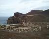
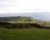
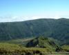
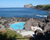
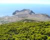
Inserted in the protected area for the habitats or species management of Capelinhos, Northwest coast and Varadouro, this route shows Fajã da Praia do Norte, greatly affected by the historical eruption of Cabeço do Fogo, in 1672. The cliff, of mist origin (detrital and lava stone), constitutes the Geosite of the Fossil Cliff of Praia do Norte and represents an important place for the settlement of the population due to its micro climate that allowed the production of vineyards, wine cellars construction and summer houses.

Cabeço do Canto

Trail Information
Category - Circular
Difficulty - Medium
Extension - 2.6 km
Time average - 2h00
Trail Info

Inserted in the area of protected landscape of the Central Area, this route allows us to go through areas of great volcanic interest like the volcanic ridge of Península do Cabeço, a Geosite with around 20 volcanic cones, from Cabeço dos Trinta until Capelinhos. Along the trail the marks change between the white, red and yellow from the intersection of Grand and Small Route and yellow and red from Small Route. The crossings are properly marked on site, with signaling arrows.

Faial

NATURE

The Blue Island

GEOGRAPHY

The 21 km in length and 14 km at the maximum width provide the 173.1 sq. km of the island of Faial with a pentagonal shape. Faial is the third most populous island of the Archipelago with 14,994 inhabitants (2011 data). The island is part of the Central Group and is the westernmost corner of the so-called “Triangle Islands”, which also include São Jorge and Pico, the latter just 6 km away from Faial. The island’s highest point is the Cabeço Gordo (1,043 m of altitude) in the Caldeira area located at 38º34’34’’ latitude north and 28º42’47’’ longitude west.

Pages

Subscribe to RSS - Faial