Fajã da Caldeira do Santo Cristo

Pico

Caminho das Lagoas

Trail Information
Category - Linear
Difficulty - Easy
Extension - 22.2 km
Time average - 7h
Trail Info

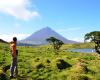
This trail is a journey through the island’s interior and its pure state.

The trail begins at Estrada Transversal, nearby the forest services’ house, and ends in the parish of Ribeirinha.

Along the trail, you will find the lakes of Caiado, Lagoa Seca, Lagoas do Peixinho, Lagoa do Paúl, among others. There are also some high-altitude pastures.

When taking this trail, you will also go through the Caveiro Nature Reserve.

Canadas da Ribeirinha

Trail Information
Category - Linear
Difficulty - Easy
Extension - 8.7 km
Time average - 4h00
Trail Info

This route going through Northeast of Pico, connects Terra Alta to Calhau.

Begin the trail near the main road (ER 1), on a land alley, Caminho da Atalhada, where it is possible to see relheiras (ancient marks done by the ox carts) printed on the ground.

Mistérios do Sul do Pico

Trail Information
Category - Linear
Difficulty - Easy
Extension - 8.5 km
Time average - 3h
Trail Info

The walking trail of “Mistérios do Sul do Pico” starts in the Forest Reserve and Recreation Park of Mistério de São João and includes the "Mistério de São João" and the "Mistério da Silveira", which are testimonies of the lava torrents passage, resulting from the historical volcanic eruptions of 1718 and 1720, respectively. The word "mistérios", which translates as “mysteries”, is due to the lack of knowledge and fear that these natural phenomena caused to the Azorean population.

Pico

Location and Climate

Pico (sharp point) obviously named after the majestic mountaintop emerging from the island, belongs to the Central Group.

It has a total area of 447 km2, is 42 km long and 15.2 km wide at its most, running from the NW to the SE.

It is the second largest island of the archipelago, at a distance of 4,5 miles from Faial, and 11 miles from San Jorge.

Position: 28º 20' W and 38º 30' N.

English

Santana – Lajido

Trail Information
Category - Linear
Difficulty - Easy
Extension - 8.7 km
Time average - 2h30m
Trail Info

This trail begins at the regional road on the border between the villages of Santana and São Vicente Ferreira.Before starting the trail visit the whale lookout by walking along the access lane on the left.

Start this route on a route between two houses which lies upstream. After 700m, turn right to an asphalt road and, soon after, start the descent towards the Gasparal Bay amid orchards and vineyards.

Prainha do Norte

Trail Information
Category - Circular
Difficulty - Easy
Extension - 7.8 km
Time average - 2h30
Trail Info

This short circular route begins in the garden at the centre of Prainha do Norte.

First climb up a lane which crosses small cultivated fields until you come to a tunnel, which leads to a path called the “Caminho da Ribeira de Nossa Senhora”, where there is a group of houses, most of which have been abandoned, lying on the opposite bank of the stream which runs alongside the path. Beautiful stone bridges have been built across the stream, giving access to the first houses built in this area, which today are part of the Non-movable Heritage of Pico Island.

Pages

Subscribe to RSS - Pico