Fajã da Caldeira do Santo Cristo

São Miguel

Fajã do Mar

Trail Information
Category - Circular
Difficulty - Medium
Extension - 5 km
Time average - 2h30
Trail Info

The pedestrian route to Fajã do Mar begins and ends at the viewpoint of Vigia das Baleias, in the parish of Feteiras which, due to its wide views over the south coast of the island of São Miguel, was used as a support for the "lookouts" on land to observe and locate the whales, representing an important testimony of the history of whaling, which had economic importance in the Azores in the last century, and continues to be used today, but for the purposes of the tourist activity of "whale watching".

Pico das Camarinhas - Ponta da Ferraria

Trail Information
Category - Circular
Difficulty - Easy
Extension - 3.6 km
Time average - 02h30
Trail Info

The trail of Pico das Camarinhas – Ponta da Ferraria begins near the viewpoint of Ilha Sabrina, known like that due to an historical volcanic eruption in 1811 that gave birth to a small Island about 6 km southeast of Ponta da Ferraria. This new island, extremely vulnerable to the erosive action of the waves, disappeared a few months later and today there is only a low-lying area.

Vigia da Baleia

Trail Information
Category - Linear
Difficulty - Medium
Extension - 7 km
Time average - 3h00
Trail Info

This linear route connects the town of Povoação to the village of Faial da Terra, a connection between the geosites of Caldeira of Povoação and the stream valley of Faial da Terra and Fajã do Calhau. Begin the walk by the road accessing Lomba dos Pós and follow the marks until you find a dirt road, on the right hand side that formerly connected the two villages. Along the way, it is still possible to do sidewalks done in the past by the local population.

Quatro Caminhos do Faial da Terra

Trail Information
Category - Circular
Difficulty - Medium
Extension - 7.5 km
Time average - 3h00
Trail Info

This circular route through the village of Faial da Terra develops partially in the geosite of Caldeira of Povoação. Begin the walk at the center of the village and follow the marks by a road accessing agricultural fields. Along it you will cross several times the regional road, passing by the old whale watching tower, place used by the ancients to watch and locate the different cetaceans species.

Rota da Água, entre Túneis e Condutas

Trail Information
Category - Linear
Difficulty - Medium
Extension - 15 km
Time average - 5h00
Trail Info

This linear route connects the place of Remédios to the village of Água do Pau, through ancient roads used by the watermen, taking the water to the parish of Lagoa. The trail crosses several resources connected to this line of activity such as old bridges, aqueducts, clay pipelines, levadas (watercourses) and some tunnels. To cross the tunnels, it is advisable the use of lanterns and before starting the trail be sure you are suitably equipped. Along the trail, it is necessary to pay special attention for the presence of animals that should not be disturbed.

Rota da Água, Pedras Brancas

Trail Information
Category - Linear
Difficulty - Medium
Extension - 5.2 km
Time average - 2h00
Trail Info

This linear route connects the village of Ribeira Chã to Água de Pau. Begin the trail at the center of the locality, known for its museums, mainly the Sacred Art and Ethnographic, the Ethnographic Yard and Azorean Endemism as well as the Rural House of Maria dos Anjos Melo, where we can see all the history, culture and heritage of this place. Rich for its gastronomy, Ribeira Chã is known for its Italian Arum cereal flour porridge, a typical sweet of the village, done with the rhizome of the plant known on the island as Italian Arum (Arum italicum).

Água Retorta

Trail Information
Category - Circular
Difficulty - Medium
Extension - 4.8 km
Time average - 2h
Trail Info

This small circular route develops through the village of Água Retorta, near the protected area for the habitats and species management. Begin the trail near the church of Nossa Senhora da Penha de França, built between 1871 and 1885 taking advantage of the bell tower, a reminiscence of an old chapel from the 17th c. that existed here.

Nascentes de Santo António

Trail Information
Category - Linear
Difficulty - Medium
Extension - 2.8 km
Time average - 1h30m
Trail Info

Situado na costa Norte da ilha, este percurso atravessa a vila de Santo António, conhecida pelas suas várias linhas de água ao longo da colina até à zona costeira. No passado, as linhas de água encaminhavam-se para vários moinhos de água conhecidos como Moinhos da Cruz ou da Rocha, hoje utilizados para abastecimento público de água.

Quatro fábricas da Luz

Trail Information
Category - Linear
Difficulty - Easy
Extension - 2.1 km
Time average - 01h30
Trail Info

This small linear route crosses several places of great historical importance in the industrialization of the island, late 19th century - beginning of the 20th century, showing the starting of the production and distribution of electric energy through renewable sources, promoted by Eng. José Cordeiro (1867 – 1908).

Padrão das Alminhas - Salto da Farinha

Trail Information
Category - Linear
Difficulty - Medium
Extension - 4.3 km
Time average - 2h00
Trail Info

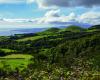
This trail connects the villages of Salga and Achadinha, passing through places of enormous natural beauty and of major historical significance.

Begin the trail near the historical monument Padrão das Alminhas, which signs the disembarking of the Liberal Forces that came from Terceira Island, August 1831, during the Portuguese Civil War (1828 – 1834).Follow the road towards the coast, passing next the museum Casa da Cultura João Melo. As descending, enjoy the view over the coastline.

Pages

Subscribe to RSS - São Miguel