


GR02 SJO Grande Rota de São Jorge 02 - São Jorge GR02SJO
Trail Info
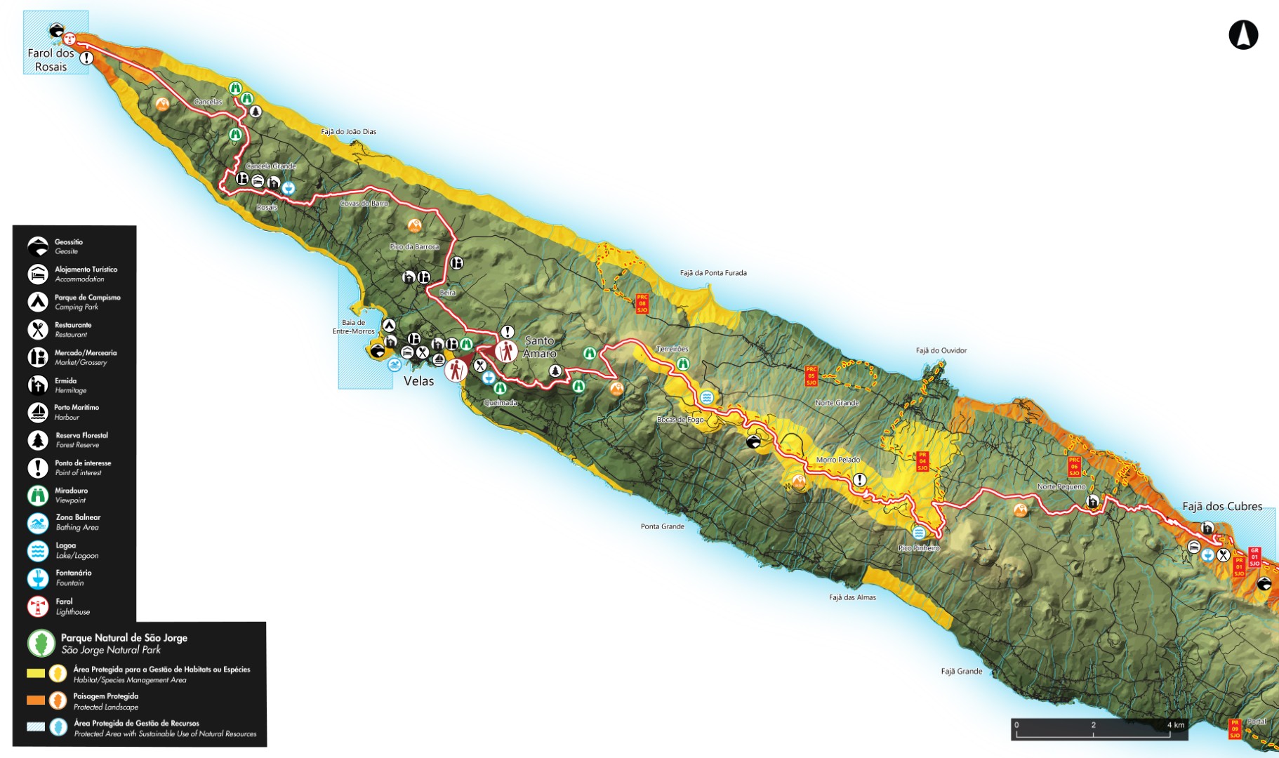
The GR02 SJO Great Route of São Jorge 02 covers approximately half of the Island, in a linear route that connects the Ponta dos Rosais (the western point of the island) to Fajã dos Cubres (on the north coast). It has an extension of approximately 52 km. On the Fajã dos Cubres, there is a possibility of connection with the GR01 SJO Great Route of São Jorge 01, that transverse the other half of the island, ending at Topo (the eastern point of the island).
This trail alternates from the plateau of the inner part of the island, where the volcanic cones that generated the Island were born, with the high, steep cliffs that come to an end in small flat areas at the sea level, the famous landscapes of the Fajãs of São Jorge.
Whenever possible, enjoy the natural bathing areas to relax and revitalize. The urban and rural centres should be used to purchase any supplies you might need for the hike.
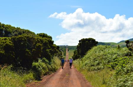
The trail is divided into two stages, of approximately 22 km and 30 km. You should plan your walk according to your physical ability, interests and availability. There are stations and designed places to spend the night (Local Lodging and Rural Tourism facilities), as wild camping is forbidden.
Contorno
Informazioni
GR02 SJO Stage 1: Ponta dos Rosais/Santo Amaro (21,8 km / 5h00)
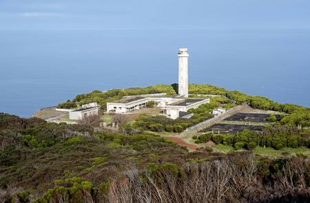
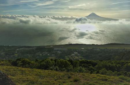
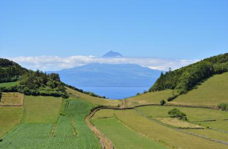
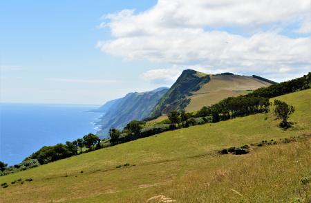
Begin the trail near the ruins of the Rosais lighthouse and to the islet of Ponta dos Rosais. Inside an area of natural monument and geosite, these cliffs of around 200 meters high represent an important area for sea birds nesting such as Cory’s shearwater (Calonectris borealis) and the Barolo shearwater (Puffinus baroli). Respect the nature preservation and be careful not to overcome the recommended limits bound by laws that protect this place. Follow the marks, passing by a detour to an old and restored Whale Watching tower from where it is possible to see the islands of Pico and Faial, on the South. Continue by the dirt road until you arrive to the Forest Park of Sete Fontes. Here, there are plant nurseries that later are transplanted to other places of the island and leisure infrastructures such as lakes, picnic areas and places for children amusement. This park is also stage of the annual feast in homage of the emigrants. At this point of the trail, it is possible to make a detour, round trip, until the viewpoints of Pico da Velha and Fajã of Ferrã Afonso, turning North, with a view over the islands of Graciosa and Terceira. With Pico island in front of you, go down, carefully due to slippery ground, towards the village of Rosais. Here you can profit to visit the Rural Exhibition Centre (Edifício Sol). The path continues through the central range of the island, towards Beira. Head office of the industrial and testing facilities of the Cooperativa de Lacticínios de São Jorge, entity that produces the famous cheese of São Jorge, tested by the Confraria do Queijo de São Jorge. Profit this locality to refill on the local commerce and continue journey on a dirt road accessing herding fields, until you reach Santo Amaro, place where this leg ends. At this point, it is possible to connect to several other points of the island through the next leg of the Grand Route, connecting Santo Amaro to Fajã dos Cubres.
GR02 SJO Stage 2 - Santo Amaro/Fajã dos Cubres (30,2 km / 10h00)
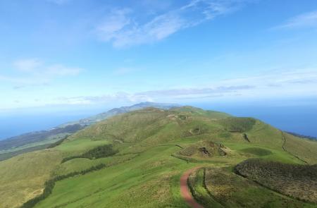
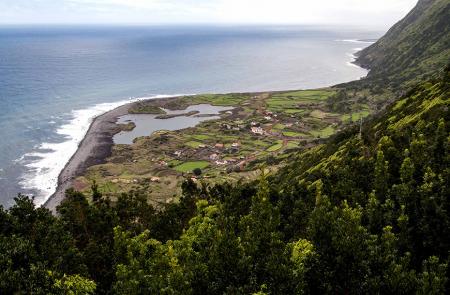
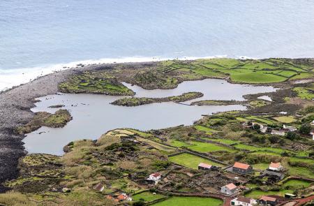
This leg connects the village of Santo Amaro (South coast) to Fajã dos Cubres (North coast), on a length of around 30 km that crosses the areas of protected landscape of Fajãs do Norte, habitat and species management of Pico da Esperança and the Central Plateau and the geosites of Fajã dos Cubres and Central Volcanic Range. This path develops partially through the central volcanic range, between 800 and 1000 meters high, being advisable to do so in days of good weather and visibility. Leave the village heading the central range of the island, crossing several volcanic cones until you arrive to the Recreational Forest Reserve of Macelas, where it is possible to visit the viewpoint of Canal with a view over Pico and Faial. Follow the marks on the road and several detours until you reach the panel PR 04 SJO – Pico do Pedro/Fajã do Ouvidor. From here, you will cross several peaks of this range such as Pico do Pedro, do Carvão, da Junça, Verde and Morro Pelado. Ahead, you will pass by Pico da Esperança, with 1053 meters high and the highest point of the island. This stage in height ends after passing Pico do Areeiro and ahead, Pico do Pinheiro, both with lakes inside their craters. Already in the North side, follow on a wood where you can find some endemic species such as Azorean heather (Erica azorica), Azorean holly (Ilex azorica) and Azores juniper (Juniperus brevifolia), until you arrive to the village of Norte Pequeno. Here you can choose to do the PRC 06 SJO – Norte Pequeno or continue, carefully along the road until Fajã dos Cubres. This leg ends in the fajã, near the chapel Ermida de Nossa Senhora de Lourdes. Here it is possible to connect to several other points of the island through the next stage of the GR 01 SJO, connecting Fajã dos Cubres to Fajã dos Vimes, or PR 01 SJO - Fajã dos Cubres/Caldeira do Santo Cristo/Serra do Topo.


