Fajã da Caldeira do Santo Cristo

São Miguel

Serra Devassa

Trail Information
Category - Circular
Difficulty - Medium
Extension - 4.9 km
Time average - 2h00
Trail Info

Integrated in a Protected Area, this small circular route in Serra Devassa allows you to walk along volcanic cones and small lakes.

This trail unfolds between an altitude of 750 to 900 meters, being advisable to walk in days of good visibility.

Caldeiras da Ribeira Grande - Salto do Cabrito

Trail Information
Category - Circular
Difficulty - Medium
Extension - 8.5 km
Time average - 2h30
Trail Info

The walking trail of Salto do Cabrito is a small circular route beginning/ending in the area of Caldeiras of Ribeira Grande. Here you can enjoy the hot springs, the recreation area as well as the bathing
facilities and restaurant.

Begin this walk going down the asphalted road until you reach the junction and follow on the left, direction Lombadas/Monte Escuro until you find a pipeline. Continue the asphalted road, around 100m and you will find, on your right hand side, a chain that you should transpose and follow along the way to gain access to the Fajã do Redondo Dam.

Rocha da Relva

Trail Information
Category - Circular
Difficulty - Medium
Extension - 5.5 km
Time average - 3h00
Trail Info

ALERT: FOR SAFETY REASONS, WE ADVISE YOU TO USE THE TRAIL UNTIL THE "PRAIA" AREA.

This roundtrip linear route until Rocha da Relva allows the hiker to visit one of the few detrital fajãs (cliffs) of São Miguel. Go down along a paved road until the first detour on the left, towards Rocha do Cascalho.

Praia da Viola

Trail Information
Category - Linear
Difficulty - Easy
Extension - 4.8 km
Time average - 2h00
Trail Info

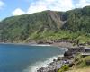
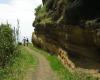
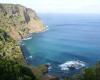
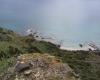
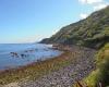
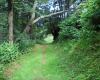
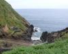
This trail, on the North coast of the island, connects the villages of Lomba da Maia to Maia, passing by one of the most beautiful natural beaches of the archipelago, Viola beach. Begin the trail at the center of the village, in front of the church Igreja Nossa Senhora do Rosário and follow the marks through the interior of the island towards the sea.

Praia – Lagoa do Fogo

Trail Information
Category - Circular
Difficulty - Medium
Extension - 11 km
Time average - 4h00
Trail Info

This linear roundtrip until the banks of Lagoa do Fogo begin in a dirt road that accesses farming lands and pastures. During the climb you will pass by the ruins of an ancient factory where fibers were produced from a plant introduced, the New Zealand flax (Phormium tenax).

Continue climbing until you reach a fork, follow right by a wood of Japanese Cedar (Cryptomeria japonica), until you arrive to a Levada (an irrigation channel), on which the trail proceeds. It is advisable to wear proper shoes due to the presence of muddy areas on the extension of the Levada.

Moinhos da Ribeira Funda

Trail Information
Category - Circular
Difficulty - Medium
Extension - 3.3 km
Time average - 2h00
Trail Info

This circular route at Ribeira Funda (Fenais da Ajuda), begins near the Chapel of Nossa Senhora da Aflição. Go down the tarred road until you reach a fork. Here, follow left by the pasture side until the entrance of a wood of Japanese Cedars (Cryptomeria japonica), Australian Cheesewood (Pittosporum undulatum), Fayatree (Morella faya), Cabaceira (Pericallis malvifolia), among others.

Mata do Canário - Sete Cidades

Trail Information
Category - Linear
Difficulty - Medium
Extension - 11.8 km
Time average - 3h00
Trail Info

This trail begins near Mata do Canário, East part of the Sete Cidades ridges, and ends at the village.

Walk down the dirt road to your right until you reach the tarmac road. Turn left, continue along the aqueduct, known as Muro das Nove Janelas, rebuilt in 1830 in order to supply Ponta Delgada.

Proceed ahead by an ascending dirt road, with japanese cedars (Cryptomeria japonica) on the left side. Go up the hillside until you reach the first viewpoint to Sete Cidades lakes, Pico da Cruz.

Lagoa das Furnas

Trail Information
Category - Circular
Difficulty - Easy
Extension - 9.5 km
Time average - 3h00
Trail Info

This circular route in Furnas begins at the parking place, at the entrance of the village, near Largo das Três Bicas.

Follow the marks along the village, passing by Igreja de Santana and Poça da Dona Beija until you reach a crossroad where you should continue towards Pico do Milho. From the top of this elevation it is possible to profit the view over the valley of Furnas.

Sanguinho

Trail Information
Category - Circular
Difficulty - Medium
Extension - 4.5 km
Time average - 2h00
Trail Info

This small circular route in Faial da Terra begins near the bus stop. Go up the asphalted road until the fork where you should continue straight by a dirt road, always along the left bank of the stream. Along the trail, the vegetation is thicker, with the Australian Cheesewood (Pittosporum undulatum) and the Australian Blackwood (Acacia melanoxylon) as predominant species.

Along the trail there are several orchards on both banks of the creek, belonging to small family farms. We ask the hikers not to pick fruits along this track.

Chá Gorreana

Trail Information
Category - Circular
Difficulty - Easy
Extension - 3.4 km
Time average - 1h30
Trail Info

This circular route along the tea plantations begins at the parking place of the Gorreana tea factory.

Working since 1883, it is the oldest tea plantation in Europe. The used plant – Camellia sinensis – for the green and black tea, was introduced in the island in 1750, brought by the ships returning from the East.

Carefully cross the gate on the way out of the factory towards the gate accessing the tea plantations.

Pages

Subscribe to RSS - São Miguel